Freshwater Ecosystems
Although two-thirds of the Earth’s surface is water, less than 1% is accessible and fresh, making freshwater one of our most precious resources.
No water, no life
Supporting life as we know it, our regional waterways (rivers, streams, lakes and wetlands) are vital for people and nature. We need freshwater for drinking, to produce and grow our food, keep clean, and manufacture nearly everything including our electricity.
Freshwater ecosystems are also rich in biodiversity, providing critical habitat for a wide variety of native plants, birds, fish, mammals and invertebrates. Many rely on different parts of waterways during different stages of their lives, including those that spend their adult lives in coastal and marine waters.
In central Queensland, freshwater is often discussed in relation to water quality because it supplies our drinking water, sustains healthy waterway ecosystems, and also because the water leaving our region ends up in the Great Barrier Reef (our region has the largest catchment draining to it). Poor water quality is a major threat to our Reef and the industries it supports because sediment, nutrients, chemicals and other pollutants transported by our waterways, damage the health of corals and many other marine species. Water quantity is also an important consideration because it determines how many plants, animals and industries our waterways can support, which in turn determines how resilient our region is to prolonged droughts, major weather events and changes to the economy.
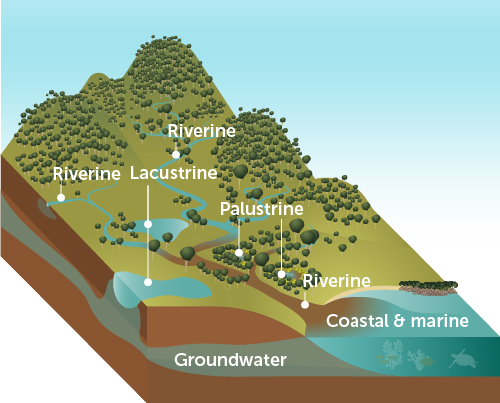
The health of our waterways depends heavily on the health of our land-based ecosystems and groundwater reserves. Likewise, our region’s groundwater and coastal and marine systems depend heavily on healthy waterways and land systems.
Diagram adapted from WetlandInfo
All freshwater ecosystems are invaluable in our region because they:
- purify and transport rain and water throughout our landscape
- are the lifeblood of our agricultural industry and most of our inland towns
- create important corridors for native animals to live and move throughout the region
- support a high diversity of native plant and animal species, many of which are threatened or facing extinction, some of which are found no-where else in the world
- provide a natural drainage system in big rain events, and storage system in dry times (sometimes providing an important source of fire-fighting water)
- help keep our landscapes cooler and wetter, which benefits people, stock and native plants and animals
- are part of our groundwater systems and influence the health of our coastal and marine ecosystems
- are part of a system that supports 20 wetlands of national significance, and two of international significance
DID YOU KNOW? The majority of water used in Queensland comes from surface water systems (approximately 95%), and about 2/3 of this is used to support our agricultural sector.
Source
Waterways receive and flush waste, and supply our drinking water
The health of freshwater environments is influenced by a range of human and environmental factors. Some are the direct result of our regional decisions and actions today, while others are the legacy of past generations. The health of our waterways is also influenced by the actions and decisions of people around the globe because of their influence on global weather patterns. Combined with our regional geology (land formations and rock types), and hydrology (the way water moves across and through our region), human behaviour and our local land management practices determine the state and health of our waterways now, creating our legacy for future generations.
The health of our rivers, streams, lakes, and wetlands in central Queensland is primarily influenced by:
- Pollution from surrounding urban, industrial and agricultural areas including rubbish, chemicals, and nutrients and sediments from soil
- Land management and building practices that create impermeable or bare ground (this leads to stronger, faster water flows that increase erosion and pollution)
- Dams, water extraction and any activities that change where and how much water flows across and through the landscape (including underground)
- Land clearing and land management practices that reduce plant-based ground cover (this changes soil water absorption, surface water flow and creates subtle changes in local weather patterns)
- Weather patterns and events, especially heavy rains, extreme storm events, and longer, hotter dry seasons
- Exotic plants and animals that change or overtake waterways, especially those that outcompete or prey on native plants and animals
- Climate change intensifies the impact of 1-6 above.
DID YOU KNOW? Of the OECD countries, Australia has one of the highest uses of water per person. Water constraints and scarcity, already a significant concern for billions of people around the world, is expected to become an even greater issue for Australians as the climate continues to warm.
Source
Discover the biggest threats to our natural assets

 Are our waterways getting the best grades possible?
In central Queensland, we are fortunate to have designated water quality monitoring and reporting for the Fitzroy Basin. The Fitzroy Partnership for River Health (FPRH) releases reports cards on the state of 20,000km of waterways within 11 freshwater catchments of the Fitzroy Basin each year. Reports indicate a mix of fair and good results and that generally, water quality is within guideline levels aimed to protect ecosystem health. Considering the extent of land clearing over the past 200 years and the fact Fitzroy Basin is a busy, working catchment, our system has proven quite resilient so far.
Because water quality trends are closely linked to hydrology and in particular, rainfall events, and because modelling shows our weather patterns are changing, anything we can do now to further safeguard our waterways is in our best interests. Reducing sediment runoff is a critical factor as it can help improve water quality and ecosystem function. Both of these will become increasingly important to us as dry spells get longer and hotter, and as our demands for food, water and housing increase.
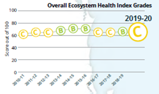
DID YOU KNOW? Our waterway report cards summarise data for various indicators collected at over 200 sites across the Fitzroy Basin. The grades are rigorously analysed and endorsed by an Independent Science Panel. The Fitzroy Basin does not include our coastal catchments, but waterway reporting soon will.
Source
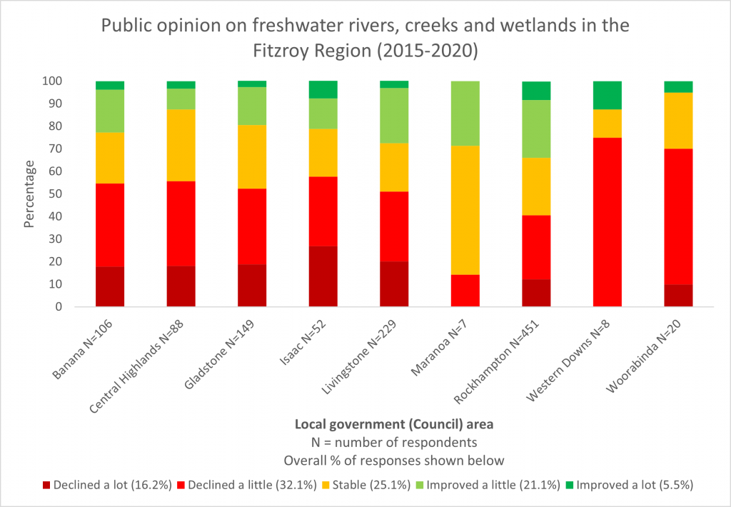
In 2020, we asked our community how they thought the health of freshwater environments in their local government area were trending based on the preceding five years. The majority of respondents reported no change to some decline.
Time to think and talk about this! Most things are okay but current trends are borderline and could easily head downhill.
Asset status is a ready estimator based on:
- Global, Australian and Queensland reports
- The likely impact on our businesses, communities, economy and future if we change nothing in the next five years
- Results of the 2020 regional natural assets community survey
Our region is not at a point where available data can be collated and analysed using a scientifically validated model to produce an accurate report on the status of our region’s six region’s natural assets and two key drivers.


